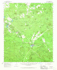
1961 Map of McNary
USGS Topo · Published 1968About this map
Mc Nary anchors the southern portion of this 1961 survey, situated along the dramatic drop-off of the Mogollon Rim. The high-altitude terrain of the Sitgreaves National Forest is defined by a series of volcanic features and drainage patterns, including Turkey Mtn and Blue Ridge Mtn. The map captures a transition in land use from the clustered settlements of Lakeside and Pinetop in the west toward the more industrial and administrative infrastructure around the Forestry Station and the various cinder pits.
Find a feature on this map
121 named features on this map. Tap any name to fly to it.
Don’t see what you’re looking for? This feature index may not catch every label — zoom into the map to look around manually.
Map Details
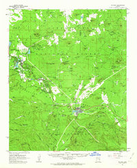
Editions of this 1961 McNary Map
2 editions found
Other maps of this area

1886 · St Johns
USGS Topo · 1:250,000

1886 · Holbrook
USGS Topo · 1:250,000

1892 · St Johns
USGS Topo · 1:250,000

1893 · Holbrook
USGS Topo · 1:250,000

1954 · Holbrook
USGS Topo · 1:250,000

1954 · Clifton
USGS Topo · 1:250,000

1954 · Saint Johns
USGS Topo · 1:250,000

1954 · Mesa
USGS Topo · 1:250,000

1957 · Mesa
USGS Topo · 1:250,000

1957 · Holbrook
USGS Topo · 1:250,000