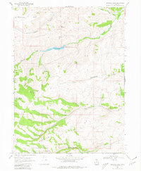
1968 Map of Meachum Ridge
USGS Topo · Published 1980About this map
Meachum Ridge dominates this high-country landscape in Rich County, where the northern reaches of the Cache National Forest meet the drainage systems of Woodruff Creek and Birch Creek. In the late 1960s, this area served as a vital water management and ranching zone, anchored by the Woodruff Creek Dam and its reservoir at Spillway Elev 6852. The presence of Walton and the Home Ranch highlights the scattered pastoral settlement patterns of the era, while a network of Jeep Trails and Pack Trails indicates the difficulty of navigating this terrain. Geological features like Red Mountain and Strawberry Ridge flank the canyons, which are dotted with numerous unnamed springs that supported both livestock and the local ecosystem. A Gaging Station on Woodruff Creek and a Borrow Pit near Walton reflect the infrastructure required to maintain this remote mountain environment.
Find a feature on this map
29 named features on this map. Tap any name to fly to it.
Don’t see what you’re looking for? This feature index may not catch every label — zoom into the map to look around manually.
Map Details
Editions of this 1968 Meachum Ridge Map
3 editions found
Other maps of this area

1912 · Randolph
USGS Topo · 1:125,000

1954 · Ogden
USGS Topo · 1:250,000

1958 · Ogden
USGS Topo · 1:250,000

1960 · Ogden
USGS Topo · 1:250,000

1968 · Horse Ridge
USGS Topo · 1:24,000

1968 · Dairy Ridge
USGS Topo · 1:24,000

1968 · Woodruff
USGS Topo · 1:24,000

1968 · Mc Kay Hollow
USGS Topo · 1:24,000

1968 · Meachum Ridge
USGS Topo · 1:24,000

1968 · Peck Canyon
USGS Topo · 1:24,000