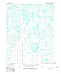
1955 Map of Meade River A-2
USGS Topo · Published 1981About this map
Singiluk stands as a central point of interest in this mid-century Arctic landscape, situated within a vast network of thaw lakes and meandering watercourses. The drainage of the Meade River dominates the western portion of the terrain, while the Usuktuk River and its associated Winter Tractor Trail define the eastern reach. This area is characterized by low-relief wetlands and oriented lakes typical of the North Slope, where seasonal transportation relied heavily on overland routes like the Winter Trail. Numerous smaller tributaries including Agutiroak Creek, Pisiksagiavik Cr, and Piksiksak Creek cut through the tundra, illustrating the complex hydrological patterns of the Alaskan interior before modern development. The mapping reflects the mid-1950s period of systematic Arctic documentation conducted by the Army Map Service.
Find a feature on this map
10 named features on this map. Tap any name to fly to it.
Don’t see what you’re looking for? This feature index may not catch every label — zoom into the map to look around manually.
Map Details
Editions of this 1955 Meade River A-2 Map
3 editions found
Other maps of this area

1951 · Meade River
USGS Topo · 1:250,000

1951 · Lookout Ridge
USGS Topo · 1:250,000

1955 · Meade River
USGS Topo · 1:250,000

1955 · Meade River A-3
USGS Topo · 1:63,360

1955 · Meade River B-1
USGS Topo · 1:63,360

1955 · Meade River B-3
USGS Topo · 1:63,360

1955 · Meade River A-2
USGS Topo · 1:63,360

1955 · Meade River B-2
USGS Topo · 1:63,360
1955 · Meade River A-1
USGS Topo · 1:63,360

1956 · Lookout Ridge
USGS Topo · 1:250,000