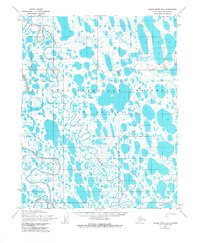
1955 Map of Meade River B-2
USGS Topo · Published 1983About this map
National Petroleum Reserve in Alaska dominates this 1950s landscape, an era when the Arctic coastal plain was being methodically documented by the Army Map Service. The terrain is a complex network of thaw lakes and meandering waterways, primarily defined by the serpentine path of the Meade River as it flows north toward the Arctic Ocean. The drainage system is supported by tributaries like the Usuktuk River and Pikroka Cr, which carve through the tundra. This survey captures a moment before significant modern development, where the only sign of inland movement across the permafrost is a single Tractor Trail cutting through the northeastern sections. The map reveals the intricate hydrology of the North Slope, where countless unnamed lakes and marshes dictated the path of early Arctic exploration and resource management.
Find a feature on this map
5 named features on this map. Tap any name to fly to it.
Don’t see what you’re looking for? This feature index may not catch every label — zoom into the map to look around manually.
Map Details
Editions of this 1955 Meade River B-2 Map
2 editions found
Other maps of this area

1951 · Meade River
USGS Topo · 1:250,000

1955 · Meade River
USGS Topo · 1:250,000

1955 · Meade River A-3
USGS Topo · 1:63,360

1955 · Meade River B-1
USGS Topo · 1:63,360

1955 · Meade River B-3
USGS Topo · 1:63,360

1955 · Meade River A-2
USGS Topo · 1:63,360

1955 · Meade River B-2
USGS Topo · 1:63,360

1955 · Meade River C-1
USGS Topo · 1:63,360
1955 · Meade River A-1
USGS Topo · 1:63,360

1955 · Meade River C-3
USGS Topo · 1:63,360