
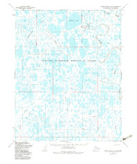
1955 Map of Meade River B-3
USGS Topo · Published 1987About this map
The Atqasuk settlement area on the North Slope reflects the remote aviation and winter transport patterns of the mid-1950s. Located within the National Petroleum Reserve in Alaska, this landscape is defined by an intricate network of thaw lakes and wandering waterways like the Meade River and Usuktuk River. The presence of a Landing Strip and a Mine near the riverbank indicates the early industrial and logistical footprint in this Arctic environment. Traditional travel routes are marked by several iterations of a Winter Trail and a general Trail that navigate between Ikmakrak Lake and Kigakrak Lake. The map captures a moment when traditional land use intersected with strategic resource management, evidenced by the scattered Ruins, a Cabin, and the distinct Corporate Boundary near the confluence of major tributaries.
Find a feature on this map
18 named features on this map. Tap any name to fly to it.
Don’t see what you’re looking for? This feature index may not catch every label — zoom into the map to look around manually.
Map Details
Editions of this 1955 Meade River B-3 Map
3 editions found
Other maps of this area

1951 · Meade River
USGS Topo · 1:250,000

1955 · Meade River
USGS Topo · 1:250,000

1955 · Meade River A-3
USGS Topo · 1:63,360

1955 · Meade River B-3
USGS Topo · 1:63,360

1955 · Meade River A-2
USGS Topo · 1:63,360
1955 · Meade River A-4
USGS Topo · 1:63,360

1955 · Meade River B-2
USGS Topo · 1:63,360

1955 · Meade River C-3
USGS Topo · 1:63,360

1955 · Meade River B-4
USGS Topo · 1:63,360

1955 · Meade River C-4
USGS Topo · 1:63,360