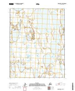
2020 Map of Meade River C-1 NE
USGS Topo · Published 2020About this map
The low-lying Arctic tundra of the North Slope is defined by a complex mosaic of thaw lakes and wetlands, where the distinction between land and water is often fluid. This modern topographic study focuses on a largely uninhabited expanse divided by the Public Land Survey System boundaries of T16n R17w, T16n R16w, T15n R17w, and T15n R16w. The landscape is a classic example of permafrost-driven geomorphology, characterized by oriented lakes and thermokarst basins that have shaped the region for millennia. With no roads or permanent settlements recorded, the map serves as a precise baseline for the hydrological state of the Alaskan coastal plain as it appeared in the early 21st century. It provides a detailed look at the intricate network of water bodies and the subtle elevation changes that dictate the flow of the northern watershed toward the Arctic Ocean.
Find a feature on this map
4 named features on this map. Tap any name to fly to it.
Don’t see what you’re looking for? This feature index may not catch every label — zoom into the map to look around manually.
Map Details
Editions of this 2020 Meade River C-1 NE Map
This is the sole edition of this map. No revisions or reprints were ever made.
Other maps of this area

1951 · Meade River
USGS Topo · 1:250,000

1951 · Teshekpuk
USGS Topo · 1:250,000

1955 · Teshekpuk
USGS Topo · 1:250,000

1955 · Teshekpuk C-5
USGS Topo · 1:63,360

1955 · Meade River
USGS Topo · 1:250,000

1955 · Meade River C-1
USGS Topo · 1:63,360
1955 · Teshekpuk D-5
USGS Topo · 1:63,360
1955 · Meade River D-1
USGS Topo · 1:63,360

1964 · Teshekpuk
USGS Topo · 1:250,000
2013 · Teshekpuk C-5 SW
USGS Topo · 1:25,000