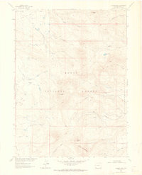
1962 Map of Meaden Peak
USGS Topo · Published 1964About this map
Meaden Peak and Sand Mountain anchor the southern reaches of this high-elevation landscape within the Routt National Forest. Surveyed in the early 1960s, the map reveals a rugged backcountry network of jeep trails and pack trails serving early ranching operations like the Jolley Ranch and Smith Ranch. The terrain is defined by dramatic summits such as Nipple Peak and Diamond Peak, which overlook a complex watershed including the South Fork Little Snake River and Willow Creek Lake. The broad openings of Slater Park and California Park contrast with the steep drainages of Torso Creek and Armstrong Creek. This mapping reflects an era of resource management and livestock grazing before modern development, where remote mountain access was limited to traditional trails and unimproved roads used by local ranchers and early forest rangers.
Find a feature on this map
28 named features on this map. Tap any name to fly to it.
Don’t see what you’re looking for? This feature index may not catch every label — zoom into the map to look around manually.
Map Details
Editions of this 1962 Meaden Peak Map
3 editions found
Other maps of this area

1911 · Hahns Peak
USGS Topo · 1:125,000

1913 · Hahns Peak
USGS Topo · 1:125,000

1923 · Pilot Knob
USGS Topo · 1:62,500

1925 · Pilot Knob
USGS Topo · 1:62,500

1954 · Craig
USGS Topo · 1:250,000

1957 · Craig
USGS Topo · 1:250,000

1958 · Craig
USGS Topo · 1:250,000

1960 · Craig
USGS Topo · 1:250,000

1962 · Craig
USGS Topo · 1:250,000
1962 · Tumble Mountain
USGS Topo · 1:24,000