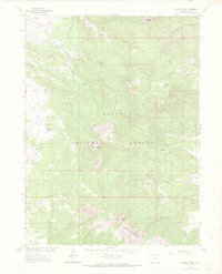
1962 Map of Meaden Peak
USGS Topo · Published 1972About this map
Meaden Peak and the surrounding high country of the Routt National Forest are documented in this 1962 field-checked survey, capturing the ranching and timber landscape of northern Colorado. The terrain is defined by a series of prominent summits, including the distinct Nipple Peak in the north and Sand Mountain to the south. The mapping detail highlights a network of pack trails and jeep trails that navigate the drainages of the South Fork Little Snake River and Elkhead Creek.
Find a feature on this map
27 named features on this map. Tap any name to fly to it.
Don’t see what you’re looking for? This feature index may not catch every label — zoom into the map to look around manually.
Map Details
Editions of this 1962 Meaden Peak Map
3 editions found
Other maps of this area

1911 · Hahns Peak
USGS Topo · 1:125,000

1913 · Hahns Peak
USGS Topo · 1:125,000

1923 · Pilot Knob
USGS Topo · 1:62,500

1925 · Pilot Knob
USGS Topo · 1:62,500

1954 · Craig
USGS Topo · 1:250,000

1957 · Craig
USGS Topo · 1:250,000

1958 · Craig
USGS Topo · 1:250,000

1960 · Craig
USGS Topo · 1:250,000

1962 · Craig
USGS Topo · 1:250,000
1962 · Tumble Mountain
USGS Topo · 1:24,000