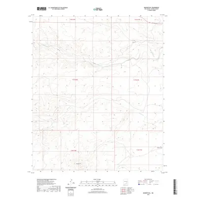
2020 Map of Meadow Hill
USGS Topo · Published 2020About this map
Rio Peñasco winds through the northern landscape of Chaves County, defining a drainage pattern that has long shaped movement in this high plains region. The terrain is characterized by intricate drainage systems, including the notable Bluewater Cr and the topographical prominence of Meadow Hill in the southwest. A network of rural routes, such as Helena Rd and Rio Penasco Rd, provides access across the township and range sections of T16S through T18S. The eastern edge of the map features Walnut Draw, illustrating the arid-land hydrology typical of this part of New Mexico. This survey is a detailed record of the physical geography and land divisions before further development or environmental shifts change the character of these watercourses.
Find a feature on this map
12 named features on this map. Tap any name to fly to it.
Don’t see what you’re looking for? This feature index may not catch every label — zoom into the map to look around manually.
Map Details
Editions of this 2020 Meadow Hill Map
This is the sole edition of this map. No revisions or reprints were ever made.
Other maps of this area

1954 · Carlsbad
USGS Topo · 1:250,000

1958 · Carlsbad
USGS Topo · 1:250,000

1960 · Teel Ranch
USGS Topo · 1:62,500

1962 · Dunken
USGS Topo · 1:62,500

1965 · Lewis Peak NE
USGS Topo · 1:24,000

1965 · Lewis Peak
USGS Topo · 1:24,000

1978 · Encino Draw
USGS Topo · 1:24,000

1978 · Artesia
USGS Topo · 1:100,000

1979 · Alamogordo
USGS Topo · 1:100,000
1989 · Sixteenmile Draw West
USGS Topo · 1:24,000