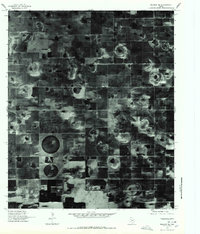
1976 Map of Meadow SE
USGS Topo · Published 1978About this map
Lakeview stands as the primary namesake settlement in this 1976 orthophotoquad, which captures the distinct land-use patterns of the High Plains south of Lubbock. This specialized imagery, produced by the United States Geological Survey from high-altitude aerial photography, provides an unfiltered view of the agricultural geometry of the region. The map reveals the interplay between rectangular section-line roads and the circular signatures of center-pivot irrigation, a technology that was rapidly transforming West Texas farming during the mid-1970s. Interspersed throughout the fields are the dark, organic shapes of ephemeral playa lakes, which dot the landscape and offer a stark contrast to the rigid human-made boundaries of Lynn County. Unlike traditional line-drawn maps, this rectified photoimagery documents the exact density of farmsteads and rural development as they existed during the Bicentennial era.
Find a feature on this map
1 named feature on this map. Tap any name to fly to it.
Don’t see what you’re looking for? This feature index may not catch every label — zoom into the map to look around manually.
Map Details
Editions of this 1976 Meadow SE Map
This is the sole edition of this map. No revisions or reprints were ever made.
Other maps of this area

1954 · Lubbock
USGS Topo · 1:250,000

1954 · Brownfield
USGS Topo · 1:250,000

1957 · New Home
USGS Topo · 1:62,500

1957 · Meadow
USGS Topo · 1:62,500

1958 · Brownfield
USGS Topo · 1:250,000

1962 · Brownfield
USGS Topo · 1:250,000

1969 · Brownfield East
USGS Topo · 1:24,000

1969 · Mound Lake
USGS Topo · 1:24,000

1969 · Double Lakes
USGS Topo · 1:24,000

1976 · New Home NW
USGS Topo · 1:24,000