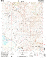
2004 Map of Meddler Wash
USGS Topo · Published 2007About this map
Tonto National Forest lands dominate this mid-2000s landscape, where the confluence of several vital drainages meets the northern reaches of Theodore Roosevelt Lake. The terrain is defined by dramatic elevation changes, from the heights of Hackberry Mountain and Black Mesa down to the low-lying waters of Campaign Bay. Traces of ranching and land management are visible through scattered features like the Bar Eleven Ranch and numerous unnamed corrals. The water-focused economy and infrastructure of the Gila County area are evidenced by the Bureau of Reclamation works and a prominent Diversion Dam along the Salt River. Historically minded researchers can find evidence of early 20th-century exploration through several Prospect sites, an Adit, and various Drill Holes scattered near Walnut Canyon and Tin Shack Spring.
Find a feature on this map
45 named features on this map. Tap any name to fly to it.
Don’t see what you’re looking for? This feature index may not catch every label — zoom into the map to look around manually.
Map Details
Editions of this 2004 Meddler Wash Map
This is the sole edition of this map. No revisions or reprints were ever made.
Other maps of this area

1907 · Roosevelt
USGS Topo · 1:125,000

1909 · Four Peaks
USGS Topo · 1:125,000

1912 · Roosevelt
USGS Topo · 1:125,000

1922 · Chrysotile
USGS Topo · 1:125,000

1949 · McFadden Peak
USGS Topo · 1:62,500

1949 · Rockinstraw Mtn
USGS Topo · 1:62,500

1950 · Rockinstraw Mtn
USGS Topo · 1:62,500

1950 · McFadden Peak
USGS Topo · 1:62,500

1954 · Mesa
USGS Topo · 1:250,000

1957 · Mesa
USGS Topo · 1:250,000