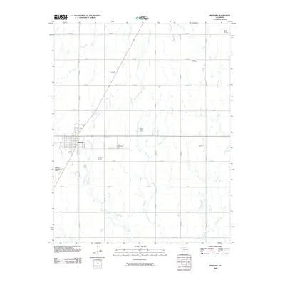
2009 Map of Medford
USGS Topo · Published 2009About this map
Medford serves as the focal point of this northern Oklahoma prairie landscape, where the town's grid is bisected by the primary railroad and highway corridor. The surrounding terrain is defined by a dense section-line road network that organizes the agricultural and industrial activity of the early 21st century. Notable local heritage is preserved in several rural burial grounds, including the Czecko Slovak Cemetery and Tureck Cemetery, reflecting the area's ancestral settlement patterns. The local economy and infrastructure are highlighted by the presence of the Numa Oil Field and aviation facilities like the CC and M Airport and Medford Municipal Airport. Drainage across the county is managed by a series of meandering waterways, most notably Bullwacker Creek and Cottonwood Creek, which weave through the structured agricultural plots.
Find a feature on this map
30 named features on this map. Tap any name to fly to it.
Don’t see what you’re looking for? This feature index may not catch every label — zoom into the map to look around manually.
Map Details
Editions of this 2009 Medford Map
This is the sole edition of this map. No revisions or reprints were ever made.
Other maps of this area

1955 · Enid
USGS Topo · 1:250,000

1958 · Enid
USGS Topo · 1:250,000

1968 · Lamont NW
USGS Topo · 1:24,000

1968 · Deer Creek
USGS Topo · 1:24,000

1968 · Wakita SE
USGS Topo · 1:24,000

1968 · Renfrow
USGS Topo · 1:24,000

1968 · Medford
USGS Topo · 1:24,000

1968 · Lamont
USGS Topo · 1:24,000
1968 · Medford NE
USGS Topo · 1:24,000

1968 · Pond Creek
USGS Topo · 1:24,000