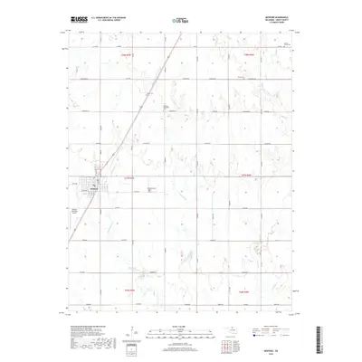
2018 Map of Medford
USGS Topo · Published 2018About this map
Medford stands as the primary hub of this north-central Oklahoma landscape, where the Jeffersonian grid of the Public Land Survey System is etched deeply into the terrain. The town's structured street plan, featuring W Apache St and W Willow St, gives way to a vast agricultural expanse defined by long section roads like Johnston Rd and Jackson Rd. The region's cultural heritage is anchored by a significant number of rural burial grounds, including the Czecko Slovak Cem and Medford Mennonite Cem, which suggest the diverse ethnic and religious groups that settled these plains.
Find a feature on this map
39 named features on this map. Tap any name to fly to it.
Don’t see what you’re looking for? This feature index may not catch every label — zoom into the map to look around manually.
Map Details
Editions of this 2018 Medford Map
This is the sole edition of this map. No revisions or reprints were ever made.
Other maps of this area

1955 · Enid
USGS Topo · 1:250,000

1958 · Enid
USGS Topo · 1:250,000

1968 · Lamont NW
USGS Topo · 1:24,000

1968 · Deer Creek
USGS Topo · 1:24,000

1968 · Wakita SE
USGS Topo · 1:24,000

1968 · Renfrow
USGS Topo · 1:24,000

1968 · Medford
USGS Topo · 1:24,000

1968 · Lamont
USGS Topo · 1:24,000
1968 · Medford NE
USGS Topo · 1:24,000

1968 · Pond Creek
USGS Topo · 1:24,000