
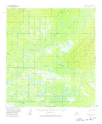
1954 Map of Medfra A-3
USGS Topo · Published 1964About this map
The confluence of the North Fork Kuskokwim River, East Fork Kuskokwim River, and South Fork Kuskokwim River dominates this mid-century interior Alaskan landscape. This complex hydrological system is characterized by thousands of small lakes, ponds, and sloughs that define the drainage basin of the main Kuskokwim River. The topography transitions from these low-lying wetlands in the west to more elevated ground in the east, where Jones Creek flows through the foothills. A lone Winter Trail in the southeast corner provides a human trace in an area otherwise devoid of named settlements or roads, reflecting the seasonal transportation patterns necessary in the subarctic. The map also records the South Boundary Kateel River Meridian, marking a critical point in the early surveying of the Alaska territory.
Find a feature on this map
7 named features on this map. Tap any name to fly to it.
Don’t see what you’re looking for? This feature index may not catch every label — zoom into the map to look around manually.
Map Details
Editions of this 1954 Medfra A-3 Map
2 editions found
Other maps of this area

1949 · McGrath
USGS Topo · 1:250,000

1950 · Medfra
USGS Topo · 1:250,000

1950 · McGrath
USGS Topo · 1:250,000

1953 · McGrath D-4
USGS Topo · 1:63,360

1953 · Medfra B-4
USGS Topo · 1:63,360

1954 · McGrath D-3
USGS Topo · 1:63,360

1955 · Medfra B-3
USGS Topo · 1:63,360

1958 · McGrath D-2
USGS Topo · 1:63,360

1958 · Medfra A-2
USGS Topo · 1:63,360

1958 · Medfra B-2
USGS Topo · 1:63,360