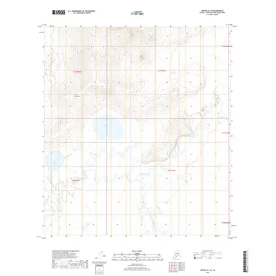
2019 Map of Medfra B-1 NE
USGS Topo · Published 2019About this map
The Telida Mountains dominate the northwestern landscape of this interior Alaska region, giving way to a complex network of waterways and wetlands to the south and east. Upper Telida Lake and Lower Telida Lake serve as central landmarks within this vast wilderness, flanked by the high ground of Tonel'ono' Mina'. The drainage system is defined by the winding course of the Swift Fork, which converges with Highpower Creek and the Shishona River as they meander through the Unorganized Borough. This 2019 survey documents a landscape where traditional landforms and modern hydrography meet, highlighting features like Mud Slough and the intricate braiding of glacial-fed streams. The map provides a detailed view of these remote geographical relationships, tracing the natural boundaries that have long shaped navigation and seasonal movement in the Yukon-Koyukuk Census Area.
Find a feature on this map
16 named features on this map. Tap any name to fly to it.
Don’t see what you’re looking for? This feature index may not catch every label — zoom into the map to look around manually.
Map Details
Editions of this 2019 Medfra B-1 NE Map
This is the sole edition of this map. No revisions or reprints were ever made.
Other maps of this area

1950 · Medfra
USGS Topo · 1:250,000

1952 · Mount McKinley
USGS Topo · 1:250,000

1958 · Medfra C-1
USGS Topo · 1:63,360

1958 · Mount McKinley B-6
USGS Topo · 1:63,360

1958 · Mount McKinley C-6
USGS Topo · 1:63,360

1958 · Mount McKinley
USGS Topo · 1:250,000

1958 · Medfra B-1
USGS Topo · 1:63,360

1959 · Medfra
USGS Topo · 1:250,000

1969 · Mount McKinley
USGS Topo · 1:250,000
2017 · Denali B-6 SW
USGS Topo · 1:25,000