
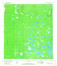
1958 Map of Mount McKinley C-6
USGS Topo · Published 1965About this map
Munsatli Ridge and the Snohomish Hills dominate the northern landscape of this interior Alaska region, giving way to a vast network of wetlands and namesake water bodies to the south. The mapping, based on aerial photography from the mid-1950s, reveals a remote wilderness where transport was largely dictated by the seasons. A significant Winter Trail cuts across the center of the sheet, providing a primary overland route through the muskeg and past numerous lakes such as Thirtyeight Mile Lake, Fortymile Lake, and Sprucefish Lake. Isolated Cabins are noted near the intersection of these trails and waterways, likely serving as essential shelter for trappers or travelers navigating the drainage basins of Highpower Creek and Lonestar Creek. The sheer density of named lakes, including Spirit Lake, Otter Lake, and Big Lake, underscores the water-saturated nature of the terrain before later development or environmental shifts altered the region's character.
Find a feature on this map
24 named features on this map. Tap any name to fly to it.
Don’t see what you’re looking for? This feature index may not catch every label — zoom into the map to look around manually.
Map Details
Editions of this 1958 Mount McKinley C-6 Map
2 editions found
Other maps of this area

1950 · Medfra
USGS Topo · 1:250,000

1952 · Mount McKinley
USGS Topo · 1:250,000

1953 · Mount McKinley C-5
USGS Topo · 1:63,360

1953 · Mount McKinley B-5
USGS Topo · 1:63,360

1953 · Mount McKinley D-5
USGS Topo · 1:63,360

1954 · Mount McKinley D-5
USGS Topo · 1:63,360

1954 · Mount McKinley B-5
USGS Topo · 1:63,360

1954 · Mount McKinley C-5
USGS Topo · 1:63,360

1958 · Medfra C-1
USGS Topo · 1:63,360

1958 · Medfra D-1
USGS Topo · 1:63,360