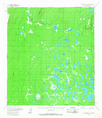
1958 Map of Mount McKinley C-6
USGS Topo · Published 1967About this map
Snohomish Hills and the prominent Munsatli Ridge dominate the northern terrain of this Alaska interior quadrangle during the mid-1950s. The landscape is a complex web of muskeg and water, defined by a dense concentration of named lakes such as Fish Creek Lake, Thirtyeight Mile Lake, and Sprucefish Lake. Transport through this wilderness relies on established routes like the Winter Trail and various other marked trails, which connect remote outposts and unnamed cabins to larger water bodies like Lake Snohomish. The presence of Carls Cache Lake and Otter Lake in the southeast suggests a landscape shaped by subsistence trapping and seasonal travel. This 1958 survey captures a remote subarctic environment before significant modern development, where the network of drainages like Fish Creek and Lonestar Creek dictated movement across the Yukon-Koyukuk region.
Find a feature on this map
24 named features on this map. Tap any name to fly to it.
Don’t see what you’re looking for? This feature index may not catch every label — zoom into the map to look around manually.
Map Details
Editions of this 1958 Mount McKinley C-6 Map
2 editions found

Other maps of this area

1950 · Medfra
USGS Topo · 1:250,000

1952 · Mount McKinley
USGS Topo · 1:250,000

1953 · Mount McKinley C-5
USGS Topo · 1:63,360

1953 · Mount McKinley B-5
USGS Topo · 1:63,360

1953 · Mount McKinley D-5
USGS Topo · 1:63,360

1954 · Mount McKinley D-5
USGS Topo · 1:63,360

1954 · Mount McKinley B-5
USGS Topo · 1:63,360

1954 · Mount McKinley C-5
USGS Topo · 1:63,360

1958 · Medfra C-1
USGS Topo · 1:63,360

1958 · Medfra D-1
USGS Topo · 1:63,360