
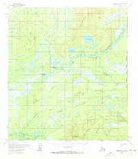
1958 Map of Medfra B-1
USGS Topo · Published 1966About this map
Telida sits at the heart of this interior Alaskan landscape, serving as a focal point along the complex drainage of the Swift Fork Kuskokwim River. The 1950s era survey documents a remote subsistence environment where a local Cem, multiple Landing Strips, and a Cabin represent the primary human infrastructure amidst a web of waterways. The terrain is defined by the Telida Mountains to the north and the Kuskokwim Hills to the south, with the lowlands between them dominated by Upper Telida Lake and Lower Telida Lake. A designated Winter Trail provides seasonal land access, cutting across the marshes and through the higher ground of Grayling Hill. The presence of identified Ruins near the riverbanks suggests shifting patterns of settlement or seasonal use along the Middle Fork Kuskokwim River and its various tributaries like Highpower Creek.
Find a feature on this map
20 named features on this map. Tap any name to fly to it.
Don’t see what you’re looking for? This feature index may not catch every label — zoom into the map to look around manually.
Map Details
Editions of this 1958 Medfra B-1 Map
2 editions found
Other maps of this area

1950 · Medfra
USGS Topo · 1:250,000

1952 · Mount McKinley
USGS Topo · 1:250,000

1958 · Medfra A-2
USGS Topo · 1:63,360

1958 · Medfra C-2
USGS Topo · 1:63,360

1958 · Medfra B-2
USGS Topo · 1:63,360

1958 · Medfra C-1
USGS Topo · 1:63,360

1958 · Medfra A-1
USGS Topo · 1:63,360

1958 · Mount McKinley B-6
USGS Topo · 1:63,360

1958 · Mount McKinley A-6
USGS Topo · 1:63,360

1958 · Mount McKinley C-6
USGS Topo · 1:63,360