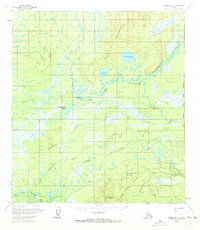
1958 Map of Medfra B-1
USGS Topo · Published 1972About this map
Telida sits at the northern edge of a complex wetland system where the Swift Fork Kuskokwim River and several tributaries converge. This mid-century survey illustrates a remote landscape centered around the upper reaches of the Kuskokwim drainage, featuring the Telida Mountains and Grayling Hill. The map provides a rare look at local infrastructure before modern development, documenting Landing Strips, a Cem, and scattered Cabins. Transport in this subarctic environment is defined by seasonal routes, notably the Winter Trail and a network of waterways including Telidaside Creek and the Slow Fork Kuskokwim River. The transition between the open water of Upper Telida Lake and the marshy expanses around Bear Island Lake reflects the region's interior drainage patterns. Evidence of previous habitation appears near the primary settlement, marked simply as Ruins.
Find a feature on this map
28 named features on this map. Tap any name to fly to it.
Don’t see what you’re looking for? This feature index may not catch every label — zoom into the map to look around manually.
Map Details
Editions of this 1958 Medfra B-1 Map
2 editions found

Other maps of this area

1950 · Medfra
USGS Topo · 1:250,000

1952 · Mount McKinley
USGS Topo · 1:250,000

1958 · Medfra A-2
USGS Topo · 1:63,360

1958 · Medfra C-2
USGS Topo · 1:63,360

1958 · Medfra B-2
USGS Topo · 1:63,360

1958 · Medfra C-1
USGS Topo · 1:63,360

1958 · Medfra A-1
USGS Topo · 1:63,360

1958 · Mount McKinley B-6
USGS Topo · 1:63,360

1958 · Mount McKinley A-6
USGS Topo · 1:63,360

1958 · Mount McKinley C-6
USGS Topo · 1:63,360