
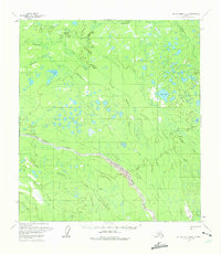
1958 Map of Mount McKinley B-6
USGS Topo · Published 1965About this map
The Swift Fork River dominates this interior Alaskan landscape, shown here as it was surveyed in the 1950s. The region is characterized by a complex network of waterways and glacially-formed basins, including the sizable Shisnona Lake and Carey Lake. These water bodies are connected by numerous drainages such as Shisnona River, Highpower Creek, and Fish Creek, illustrating a classic subarctic drainage pattern where water dominates the low-lying muskeg and tundra.
Find a feature on this map
17 named features on this map. Tap any name to fly to it.
Don’t see what you’re looking for? This feature index may not catch every label — zoom into the map to look around manually.
Map Details
Editions of this 1958 Mount McKinley B-6 Map
2 editions found
Other maps of this area

1950 · Medfra
USGS Topo · 1:250,000

1952 · Mount McKinley
USGS Topo · 1:250,000

1952 · Mount McKinley A-5
USGS Topo · 1:63,360

1953 · Mount McKinley C-5
USGS Topo · 1:63,360

1953 · Mount McKinley B-5
USGS Topo · 1:63,360

1954 · Mount McKinley B-5
USGS Topo · 1:63,360

1954 · Mount McKinley A-5
USGS Topo · 1:63,360

1954 · Mount McKinley C-5
USGS Topo · 1:63,360

1958 · Medfra C-1
USGS Topo · 1:63,360

1958 · Medfra A-1
USGS Topo · 1:63,360