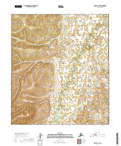
2019 Map of Medfra D-3 NE
USGS Topo · Published 2019About this map
Sulukna River winds through the heart of this landscape in the Yukon-Koyukuk Census Area, tracing a complex series of meanders and oxbow lakes across the interior Alaska wilderness. This 2019 survey documents the intricate natural hydrology of the river valley, where the watercourse shifts through a system of low-lying wetlands and brush-covered flats. The map provides precise detail on the topographical contours that define the drainage patterns of the river, which serves as the primary geographic feature of the region. The absence of roads or established settlements on the map underscores the isolation of the area, typical of the vast unpopulated stretches of central Alaska where travel relies largely on the seasonal flow of the river or traversing the open wilderness between township boundaries.
Find a feature on this map
7 named features on this map. Tap any name to fly to it.
Don’t see what you’re looking for? This feature index may not catch every label — zoom into the map to look around manually.
Map Details
Editions of this 2019 Medfra D-3 NE Map
This is the sole edition of this map. No revisions or reprints were ever made.
Other maps of this area

1950 · Medfra
USGS Topo · 1:250,000

1951 · Ruby
USGS Topo · 1:250,000

1952 · Ruby A-2
USGS Topo · 1:63,360

1952 · Ruby A-3
USGS Topo · 1:63,360

1952 · Ruby
USGS Topo · 1:250,000
1954 · Medfra D-3
USGS Topo · 1:63,360

1958 · Medfra D-2
USGS Topo · 1:63,360

1959 · Medfra
USGS Topo · 1:250,000

1964 · Ruby
USGS Topo · 1:250,000
2019 · Medfra D-3 NW
USGS Topo · 1:25,000