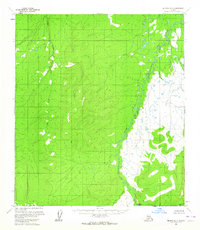
1954 Map of Medfra D-3
USGS Topo · Published 1964About this map
The Sulukna River meanders through the heart of this mid-century Alaskan interior landscape, a region defined by its lack of roads and settlements. Recorded during aerial surveys in the early 1950s, the terrain is characterized by a complex network of drainage systems feeding into the main river channel. Smaller tributaries such as Our Creek and Granite Creek snake through the topographic contours, eventually joining the larger waterways. At the southern reaches, the Browns Fork marks a significant intersection in the hydrological pattern of the Yukon-Koyukuk region. This map presents a pure representation of the Alaskan wilderness before any modern infrastructure or industrial development reached this specific quadrangle, making it an essential reference for understanding the untouched natural drainage of the territory during the post-war era.
Find a feature on this map
4 named features on this map. Tap any name to fly to it.
Don’t see what you’re looking for? This feature index may not catch every label — zoom into the map to look around manually.
Map Details
Editions of this 1954 Medfra D-3 Map
This is the sole edition of this map. No revisions or reprints were ever made.
Other maps of this area

1950 · Medfra
USGS Topo · 1:250,000

1951 · Ruby
USGS Topo · 1:250,000

1952 · Ruby A-2
USGS Topo · 1:63,360

1952 · Ruby A-3
USGS Topo · 1:63,360

1952 · Ruby A-4
USGS Topo · 1:63,360

1952 · Ruby
USGS Topo · 1:250,000

1953 · Medfra C-4
USGS Topo · 1:63,360

1954 · Medfra C-3
USGS Topo · 1:63,360
1954 · Medfra D-4
USGS Topo · 1:63,360

1958 · Medfra D-2
USGS Topo · 1:63,360