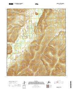
2019 Map of Medfra D-4 NE
USGS Topo · Published 2019About this map
The Nowitna River meanders through the heart of this interior landscape in the Yukon-Koyukuk Census Area. This remote terrain is defined by its complex hydrography, where the river's winding course creates numerous oxbows and abandoned channels across the low-lying flats. To the west, Pilot Cr joins the larger drainage system, carving a path through the varied elevations that rise away from the river valley. The map provides a precise look at the township and range divisions, including t17s r21e and t18s r22e, which structure this largely untouched wilderness. Geologists and environmental researchers can examine the contour patterns that illustrate the gradual transition from riparian zones to the surrounding uplands in this corner of the Alaskan interior.
Find a feature on this map
8 named features on this map. Tap any name to fly to it.
Don’t see what you’re looking for? This feature index may not catch every label — zoom into the map to look around manually.
Map Details
Editions of this 2019 Medfra D-4 NE Map
This is the sole edition of this map. No revisions or reprints were ever made.
Other maps of this area

1950 · Medfra
USGS Topo · 1:250,000

1951 · Ruby
USGS Topo · 1:250,000

1952 · Ruby A-3
USGS Topo · 1:63,360

1952 · Ruby A-4
USGS Topo · 1:63,360

1952 · Ruby
USGS Topo · 1:250,000
1954 · Medfra D-3
USGS Topo · 1:63,360
1954 · Medfra D-4
USGS Topo · 1:63,360

1959 · Medfra
USGS Topo · 1:250,000

1964 · Ruby
USGS Topo · 1:250,000
2019 · Medfra D-4 SE
USGS Topo · 1:25,000