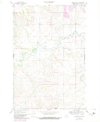
1968 Map of Medicine Butte
USGS Topo · Published 1980About this map
Medicine Butte rises as a prominent landmark in this Mercer County landscape, overseeing the winding course of the Knife River. This 1960s survey, updated in 1980, captures a quiet rural expanse where the terrain is shaped by the drainage systems of Coyote Creek and Mud Creek. The map documents the local industry of the era, marking the presence of a Strip Mine and Gravel Pit in the northern reaches, signaling the importance of mineral extraction to the regional economy. Beyond the natural watercourses, a large Pipeline traverses the township lines, reflecting the modern infrastructure overlaying the traditional prairie landscape. Photogrammetric methods from 1967 and 1977 provide a high level of detail for fencelines and field boundaries, making this an essential record for understanding land use and property divisions in this part of North Dakota.
Find a feature on this map
7 named features on this map. Tap any name to fly to it.
Don’t see what you’re looking for? This feature index may not catch every label — zoom into the map to look around manually.
Map Details
Editions of this 1968 Medicine Butte Map
2 editions found
Other maps of this area

1953 · Watford City
USGS Topo · 1:250,000

1954 · McClusky
USGS Topo · 1:250,000

1957 · Watford City
USGS Topo · 1:250,000

1958 · McClusky
USGS Topo · 1:250,000

1967 · Watford City
USGS Topo · 1:250,000

1968 · Beulah
USGS Topo · 1:24,000

1968 · Medicine Butte NE
USGS Topo · 1:24,000

1968 · Medicine Butte
USGS Topo · 1:24,000

1969 · Zap
USGS Topo · 1:24,000
1972 · Medicine Butte SW
USGS Topo · 1:24,000