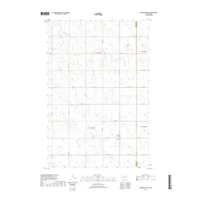
2018 Map of Medicine Butte SE
USGS Topo · Published 2018About this map
Mercer County's rural prairies and deep-rooted family history are recorded in this 2018 survey along the boundary with Oliver County. The landscape is largely defined by its township-and-range section lines and a grid of secondary roads like Co Rd 25 and Co Rd 16. For genealogists and local historians, the map's most significant markers are the dispersed burial grounds that dot the plains, including Peace Cem, Unruh Cem, New Gluecksthal Cem, and Voegele Cem. These locations reflect the area's early 20th-century settlement patterns, particularly the German-Russian heritage common to this part of the state. The terrain remains primarily agricultural, punctuated by local landmarks like 60th Ave SW and 24th St SW, which trace the high ground and coulees of the Missouri Plateau.
Find a feature on this map
27 named features on this map. Tap any name to fly to it.
Don’t see what you’re looking for? This feature index may not catch every label — zoom into the map to look around manually.
Map Details
Editions of this 2018 Medicine Butte SE Map
This is the sole edition of this map. No revisions or reprints were ever made.
Other maps of this area

1954 · Bismarck
USGS Topo · 1:250,000

1954 · McClusky
USGS Topo · 1:250,000

1958 · Bismarck
USGS Topo · 1:250,000

1958 · McClusky
USGS Topo · 1:250,000

1968 · Medicine Butte NE
USGS Topo · 1:24,000

1968 · Red Butte NW
USGS Topo · 1:24,000

1968 · Medicine Butte
USGS Topo · 1:24,000

1970 · Hailstone Butte
USGS Topo · 1:24,000

1970 · Glen Ullin NE
USGS Topo · 1:24,000
1970 · Glen Ullin NW
USGS Topo · 1:24,000