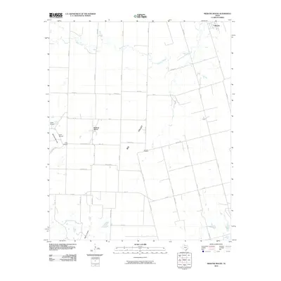
2010 Map of Medicine Mound
USGS Topo · Published 2010About this map
The Medicine Mounds rise as distinct topographic landmarks above the plains of Hardeman County, defining the character of this West Texas landscape. This 2010 survey highlights the cluster of formations including Cedar Mound, Third Mound, and Little Mound, which stand west of the small settlement of Medicine Mound. The terrain is drained by the winding path of Wanderers Creek to the north and Warrior Hollow to the south, illustrating the natural watercourses that have shaped the region. A dense grid of rural roads, such as Wisdom Rd and Hog Farm Rd, connects scattered farmsteads and agricultural operations. To the northeast, the corner of Chillicothe appears, while the Big Valley Cemetery sits as a quiet landmark within the broad expanse of the Big Valley.
Find a feature on this map
42 named features on this map. Tap any name to fly to it.
Don’t see what you’re looking for? This feature index may not catch every label — zoom into the map to look around manually.
Map Details
Editions of this 2010 Medicine Mound Map
This is the sole edition of this map. No revisions or reprints were ever made.
Other maps of this area

1955 · Lawton
USGS Topo · 1:250,000

1958 · Vernon
USGS Topo · 1:62,500

1958 · Medicine Mound
USGS Topo · 1:62,500

1958 · Elmer
USGS Topo · 1:62,500

1960 · Quanah
USGS Topo · 1:62,500

1983 · Warrior Hollow
USGS Topo · 1:24,000

1983 · Tolbert
USGS Topo · 1:24,000
1983 · Rayland
USGS Topo · 1:24,000

1983 · Big Mound
USGS Topo · 1:24,000
1983 · Margaret
USGS Topo · 1:24,000