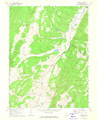
1967 Map of Medley
USGS Topo · Published 1972About this map
Patterson Creek carves a central valley through this section of the Potomac Highlands, serving as the primary corridor for settlements like Medley and Williamsport. The landscape is defined by the parallel ridges of Knobly Mountain and New Creek Mountain, where steep terrain is interrupted by strategic passages such as Harris Gap and Falls Gap. These gaps historically dictated the movement of goods and people between the narrow valley floors.
Find a feature on this map
28 named features on this map. Tap any name to fly to it.
Don’t see what you’re looking for? This feature index may not catch every label — zoom into the map to look around manually.
Map Details
Editions of this 1967 Medley Map
4 editions found
Other maps of this area

1891 · Romney
USGS Topo · 1:125,000

1895 · Piedmont
USGS Topo · 1:125,000

1919 · Elk Garden
USGS Topo · 1:48,000

1920 · Elk Garden
USGS Topo · 1:48,000

1920 · Moorefield
USGS Topo · 1:62,500

1920 · Keyser
USGS Topo · 1:62,500

1921 · Keyser
USGS Topo · 1:48,000

1921 · Greenland Gap
USGS Topo · 1:62,500

1921 · Moorefield
USGS Topo · 1:48,000

1922 · Elk Garden
USGS Topo · 1:62,500