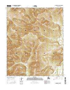
2016 Map of Melozitna B-5 NE
USGS Topo · Published 2016About this map
The interior of the Melozitna B-5 NE quadrangle is defined by the rigid grid of the Public Land Survey System, as shown in this 2016 survey. The map document is dominated by topographical data across five distinct townships: T1n R17e, T1n R18e, T1n R19e, T1s R18e, and T1s R19e. In this section of Alaska, the landscape is presented in its raw form, devoid of the named settlements, schools, or churches common to more populated regions. Instead, the focus is entirely on the elevation and the natural contours of the land, providing a base for understanding the drainage patterns and physical structure of this remote territory. This edition offers a clean, data-focused look at the township boundaries as they intersect with the natural topography, a useful resource for those tracking land allotments or studying the uninhabited geography of the Yukon-Koyukuk region.
Find a feature on this map
5 named features on this map. Tap any name to fly to it.
Don’t see what you’re looking for? This feature index may not catch every label — zoom into the map to look around manually.
Map Details
Editions of this 2016 Melozitna B-5 NE Map
This is the sole edition of this map. No revisions or reprints were ever made.
Other maps of this area

1951 · Melozitna
USGS Topo · 1:250,000

1954 · Melozitna C-4
USGS Topo · 1:63,360
1954 · Melozitna B-4
USGS Topo · 1:63,360

1954 · Melozitna C-5
USGS Topo · 1:63,360
1954 · Melozitna B-5
USGS Topo · 1:63,360

1956 · Melozitna
USGS Topo · 1:250,000
2016 · Melozitna B-5 SE
USGS Topo · 1:25,000
2016 · Melozitna C-5 SW
USGS Topo · 1:25,000
2016 · Melozitna C-5 SE
USGS Topo · 1:25,000
2016 · Melozitna B-5 SW
USGS Topo · 1:25,000