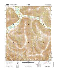
2016 Map of Melozitna C-1 SE
USGS Topo · Published 2016About this map
The interior of Alaska within the Yukon-Koyukuk region is defined by the rigid grid of the Public Land Survey System as documented in this 2016 survey. This specific quadrangle covers several townships and ranges, including T3n R27e, T3n R28e, T2n R27e, T2n R28e, T1n R27e, and T1n R28e. The landscape is dominated by a complex network of meandering watercourses and drainages that snake across the terrain, contrasting with the precise mathematical lines of the surveying boundaries. The mapping reflects the administrative organization of the Alaskan wilderness, where natural features dictate the topography while the township system provides the legal framework for land management in this sparsely populated area.
Find a feature on this map
6 named features on this map. Tap any name to fly to it.
Don’t see what you’re looking for? This feature index may not catch every label — zoom into the map to look around manually.
Map Details
Editions of this 2016 Melozitna C-1 SE Map
This is the sole edition of this map. No revisions or reprints were ever made.
Other maps of this area

1951 · Melozitna
USGS Topo · 1:250,000

1951 · Tanana
USGS Topo · 1:250,000

1956 · Melozitna C-1
USGS Topo · 1:63,360

1956 · Melozitna B-1
USGS Topo · 1:63,360

1956 · Tanana B-6
USGS Topo · 1:63,360

1956 · Tanana C-6
USGS Topo · 1:63,360

1956 · Melozitna
USGS Topo · 1:250,000

1956 · Tanana
USGS Topo · 1:250,000

1960 · Tanana
USGS Topo · 1:250,000
2016 · Tanana B-6 NW
USGS Topo · 1:25,000