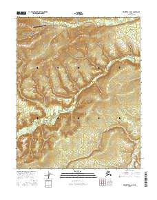
2016 Map of Melozitna D-2 NE
USGS Topo · Published 2016About this map
Indian Mountain Long Range Radar Site sits atop the high terrain in the northwestern corner of this interior Alaska quadrangle, overlooking a landscape defined by the winding course of the Indian River. This 2016 survey illustrates the intersection of strategic infrastructure and the wild Alaskan interior, where the radar installation is accessed by a complex system of ridgeline and valley roads. The drainage network is clearly defined by several significant watercourses, including Utopia Cr and Flat Cr, which flow through the steep valleys. These creeks and the river valley provide a distinct contrast to the elevated peaks that house the radar facility, offering a detailed view of the remote topographical relief and the specialized land use required for such an isolated outpost.
Find a feature on this map
8 named features on this map. Tap any name to fly to it.
Don’t see what you’re looking for? This feature index may not catch every label — zoom into the map to look around manually.
Map Details
Editions of this 2016 Melozitna D-2 NE Map
This is the sole edition of this map. No revisions or reprints were ever made.
Other maps of this area

1951 · Hughes
USGS Topo · 1:250,000

1951 · Melozitna
USGS Topo · 1:250,000

1952 · Melozitna D-1
USGS Topo · 1:63,360

1955 · Melozitna D-2
USGS Topo · 1:63,360

1955 · Hughes A-2
USGS Topo · 1:63,360

1955 · Hughes A-1
USGS Topo · 1:63,360

1956 · Hughes
USGS Topo · 1:250,000

1956 · Melozitna
USGS Topo · 1:250,000
1956 · Hughes A-2
USGS Topo · 1:63,360

1964 · Hughes
USGS Topo · 1:250,000