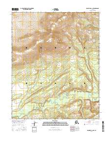
2016 Map of Melozitna D-2 NW
USGS Topo · Published 2016About this map
The Indian Mountains dominate the northern landscape of this remote Yukon-Koyukuk interior region, where steep drainage patterns descend into the broad, meandering basin of the Indian River. This 2016 survey illustrates the complex hydrology of the subarctic wilderness, capturing the intricate courses of northern tributaries like Utopia Cr and Macaroni Cr. The map details the transition from high-elevation ridgelines down to the wetland-rich flats surrounding the main river channel, providing a clear view of the natural terrain before any modern industrial or infrastructural footprints. It serves as a vital record for understanding the topographical character of the Alaskan interior in the early 21st century, defined by its watercourses and prominent mountain peaks.
Find a feature on this map
8 named features on this map. Tap any name to fly to it.
Don’t see what you’re looking for? This feature index may not catch every label — zoom into the map to look around manually.
Map Details
Editions of this 2016 Melozitna D-2 NW Map
This is the sole edition of this map. No revisions or reprints were ever made.
Other maps of this area

1951 · Hughes
USGS Topo · 1:250,000

1951 · Melozitna
USGS Topo · 1:250,000

1952 · Melozitna D-3
USGS Topo · 1:63,360

1954 · Melozitna D-3
USGS Topo · 1:63,360

1955 · Melozitna D-2
USGS Topo · 1:63,360

1955 · Hughes A-2
USGS Topo · 1:63,360

1955 · Hughes A-3
USGS Topo · 1:63,360

1956 · Hughes
USGS Topo · 1:250,000

1956 · Melozitna
USGS Topo · 1:250,000
1956 · Hughes A-3
USGS Topo · 1:63,360