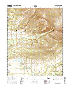
2016 Map of Melozitna D-3 NE
USGS Topo · Published 2016About this map
Pocahontas Hot Springs sits at the northern edge of this interior Alaska wilderness, situated near the headwaters of Pocahontas Cr. The landscape is dominated by significant relief, with the creek winding through a deep valley before flowing southward through t7n r22e and t7n r23e. In the southern portion of the quadrangle, the terrain transitions toward the drainage of the Indian River, which cuts across the southeastern corner. This survey by the U.S. Geological Survey provides a precise record of the hydrological patterns and elevation contours of the Yukon-Koyukuk region, capturing the remote geography of the Alaskan interior at a 1:25,000 scale.
Find a feature on this map
7 named features on this map. Tap any name to fly to it.
Don’t see what you’re looking for? This feature index may not catch every label — zoom into the map to look around manually.
Map Details
Editions of this 2016 Melozitna D-3 NE Map
This is the sole edition of this map. No revisions or reprints were ever made.
Other maps of this area

1951 · Hughes
USGS Topo · 1:250,000

1951 · Melozitna
USGS Topo · 1:250,000

1952 · Melozitna D-3
USGS Topo · 1:63,360

1954 · Melozitna D-3
USGS Topo · 1:63,360

1955 · Melozitna D-2
USGS Topo · 1:63,360

1955 · Hughes A-2
USGS Topo · 1:63,360

1955 · Hughes A-3
USGS Topo · 1:63,360

1956 · Hughes
USGS Topo · 1:250,000

1956 · Melozitna
USGS Topo · 1:250,000
1956 · Hughes A-3
USGS Topo · 1:63,360