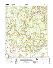
2016 Map of Melozitna D-6 NW
USGS Topo · Published 2016About this map
The Koyukuk River dominates this portion of the Alaska interior, exhibiting the complex, shifting hydrology characteristic of the region. The landscape is defined by the migration of the river channel, which has left behind an intricate network of abandoned meanders and side channels. These features are documented here through specific water bodies such as Cutoff Slough and the winding Messy Slough, which weaves through the eastern and central sections of the quadrangle. In the southern reaches, the Nayoyalna Slough marks the transition of the drainage system toward broader wetlands. This survey, grounded in data from the U.S. Geological Survey and updated with modern imagery, provides a detailed record of the hydrographic changes in the Melozitna area during the early 21st century.
Find a feature on this map
8 named features on this map. Tap any name to fly to it.
Don’t see what you’re looking for? This feature index may not catch every label — zoom into the map to look around manually.
Map Details
Editions of this 2016 Melozitna D-6 NW Map
This is the sole edition of this map. No revisions or reprints were ever made.
Other maps of this area

1951 · Shungnak
USGS Topo · 1:250,000

1951 · Kateel River
USGS Topo · 1:250,000

1951 · Hughes
USGS Topo · 1:250,000

1951 · Melozitna
USGS Topo · 1:250,000

1954 · Kateel River D-1
USGS Topo · 1:63,360

1954 · Melozitna D-6
USGS Topo · 1:63,360

1955 · Shungnak
USGS Topo · 1:250,000

1955 · Kateel River
USGS Topo · 1:250,000

1956 · Hughes
USGS Topo · 1:250,000

1956 · Melozitna
USGS Topo · 1:250,000