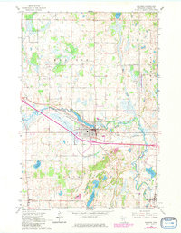
1965 Map of Melrose
USGS Topo · Published 1980About this map
The Sauk River winds through this Central Minnesota landscape, defining the industrial and social development of Melrose. The city is a clear focal point, showing the integration of the Great Northern railroad line with the local street grid, alongside municipal infrastructure like the Hospital and Sewage Disposal plant. This mid-century survey captures the region's strong Catholic heritage, evidenced by the clustered presence of St Marys Cem, St Patrick Cem, and St Johns Cem.
Find a feature on this map
36 named features on this map. Tap any name to fly to it.
Don’t see what you’re looking for? This feature index may not catch every label — zoom into the map to look around manually.
Map Details
Editions of this 1965 Melrose Map
3 editions found
Other maps of this area

1950 · Swanville
USGS Topo · 1:62,500

1953 · Saint Cloud
USGS Topo · 1:250,000

1957 · Saint Cloud
USGS Topo · 1:250,000

1958 · Saint Cloud
USGS Topo · 1:250,000

1965 · Greenwald
USGS Topo · 1:24,000

1965 · Sauk Centre
USGS Topo · 1:24,000

1965 · Melrose
USGS Topo · 1:24,000

1965 · Freeport
USGS Topo · 1:24,000

1965 · Elrosa
USGS Topo · 1:24,000

1965 · St Martin
USGS Topo · 1:24,000
Featured Places
- Melrose, MN
- New Munich, MN
- Meire Grove, MN
- Rose Terrace Mobile Home Park, Melrose
- Melrose Mobile Home Park, Melrose