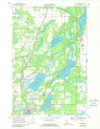
1969 Map of Menahga
USGS Topo · Published 1989About this map
Menahga serves as the focal point of this late 1960s survey, situated along the Burlington Northern line and bounded by the waters of Spirit Lake and Blueberry Lake. The landscape is defined by an intricate network of waterways where the Straight River and Shell River drain through numerous glacial basins. Near the settlement of Hubbard, the map identifies the Pine Haven Ch and a Campground, illustrating the region's development as a destination for recreation and community life.
Find a feature on this map
25 named features on this map. Tap any name to fly to it.
Don’t see what you’re looking for? This feature index may not catch every label — zoom into the map to look around manually.
Map Details
Editions of this 1969 Menahga Map
2 editions found
Other maps of this area

1953 · Brainerd
USGS Topo · 1:250,000

1957 · Brainerd
USGS Topo · 1:250,000

1958 · Brainerd
USGS Topo · 1:250,000

1965 · Brainerd
USGS Topo · 1:250,000

1969 · Park Rapids
USGS Topo · 1:24,000

1969 · Menahga
USGS Topo · 1:24,000

1969 · Park Rapids SW
USGS Topo · 1:24,000

1969 · Sebeka
USGS Topo · 1:24,000

1969 · Sebeka NW
USGS Topo · 1:24,000
1969 · Park Rapids NW
USGS Topo · 1:24,000