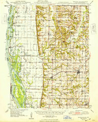
1948 Map of Mendon
USGS Topo · Published 1948About this map
Mississippi River bottomlands dominate the western half of this 1940s landscape, where a complex network of chutes and sloughs like Dillon Chute and Corner Slough surround numerous named landforms including Shandrew Island and Polly Island. The inland terrain rises sharply toward the bluffs, revealing a transition from the riparian environment to the agricultural plateaus of Mendon and Ursa. The map details the era's infrastructure before modern highway expansion, featuring the Chicago Burlington and Quincy rail line and the specialized engineering of the Rock and Ursa Creek Diversion Canal. Significant local history is preserved in the placement of numerous rural institutions, such as Mt Hebron Ch, Booth Mem Cem, and over a dozen country schoolhouses including Golden Sch and Brick Sch 36. Water access remains vital to the community, evidenced by the Canton Ferry crossing and the proximity of river towns like La Grange and Meyer.
Find a feature on this map
113 named features on this map. Tap any name to fly to it.
Don’t see what you’re looking for? This feature index may not catch every label — zoom into the map to look around manually.
Map Details
Editions of this 1948 Mendon Map
2 editions found

Other maps of this area

1903 · Kahoka
USGS Topo · 1:125,000

1903 · Palmyra
USGS Topo · 1:125,000

1925 · Quincy
USGS Topo · 1:62,500

1925 · Liberty
USGS Topo · 1:62,500

1927 · Liberty
USGS Topo · 1:62,500

1933 · Carthage
USGS Topo · 1:62,500

1936 · Keokuk
USGS Topo · 1:62,500

1937 · Carthage
USGS Topo · 1:62,500

1944 · Quincy
USGS Topo · 1:62,500

1945 · Quincy
USGS Topo · 1:62,500