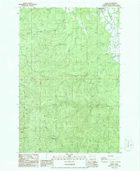
1986 Map of Menlo
USGS Topo · Published 1986About this map
The settlement of Menlo anchors the northern reaches of this Pacific County landscape, situated within the fertile Willapa Valley. The terrain is defined by a complex hydraulic network where the Willapa River meets numerous tributaries, including Rue Creek, Fall Creek, and Highland Creek. To the south, the drainage systems of the West Fork, Middle Fork, and South Fork carve through the timbered uplands. This 1980s survey illustrates a landscape primarily shaped by natural waterways and industrial resource extraction, evidenced by several Quarry and Borrow Pit sites scattered throughout the hills. The southern portion of the quadrangle transitions into the Naselle River basin, showing the divide between these two major coastal river systems. Researchers can trace the mid-century road developments and the persistent footprint of small-scale mining operations alongside named water bodies like Trap Creek and Oxbow Creek.
Find a feature on this map
20 named features on this map. Tap any name to fly to it.
Don’t see what you’re looking for? This feature index may not catch every label — zoom into the map to look around manually.
Map Details
Editions of this 1986 Menlo Map
This is the sole edition of this map. No revisions or reprints were ever made.
Other maps of this area

1938 · Fort Columbia
USGS Topo · 1:62,500

1938 · South Bend
USGS Topo · 1:62,500

1940 · Brookfield
USGS Topo · 1:62,500

1940 · South Bend
USGS Topo · 1:62,500

1943 · Fort Columbia
USGS Topo · 1:62,500

1949 · Upper Naselle River
USGS Topo · 1:24,000

1949 · Oman Ranch
USGS Topo · 1:24,000

1953 · Hoquiam
USGS Topo · 1:250,000

1955 · Grays River
USGS Topo · 1:62,500

1955 · Raymond
USGS Topo · 1:62,500