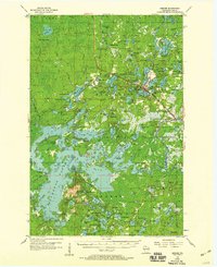
1955 Map of Mercer
USGS Topo · Published 1959About this map
The town of Mercer serves as the focal point of this mid-century survey, situated at the junction of the Chicago And Northwestern railroad and a dense network of glacial lakes. The settlement pattern reflects the area's transition into a northwoods recreation and forestry hub, with the expansive Northern Highland State Forest dominating the eastern landscape. Local civic life is anchored by the Town Hall, Mercer Cem, and the Springstead Sch to the south.
Find a feature on this map
132 named features on this map. Tap any name to fly to it.
Don’t see what you’re looking for? This feature index may not catch every label — zoom into the map to look around manually.
Map Details
Editions of this 1955 Mercer Map
4 editions found

Other maps of this area

1938 · Lac Du Flambeau
USGS Topo · 1:48,000

1939 · Lac Du Flambeau
USGS Topo · 1:48,000

1939 · Winchester
USGS Topo · 1:48,000

1940 · Mercer
USGS Topo · 1:48,000

1940 · Butternut
USGS Topo · 1:48,000

1940 · Upson
USGS Topo · 1:48,000

1941 · Park Falls
USGS Topo · 1:48,000

1941 · Pike Lake
USGS Topo · 1:48,000

1942 · Pike Lake
USGS Topo · 1:48,000

1943 · Upson
USGS Topo · 1:48,000