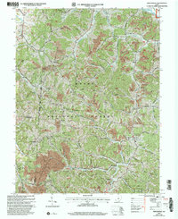
2002 Map of Mercerville
USGS Topo · Published 2006About this map
The Wayne National Forest dominates the terrain of south-central Ohio in this early 21st-century record, where the ridges of Gallia and Lawrence counties meet. This area reflects a landscape defined by natural resource extraction and conservation, evidenced by numerous Strip Mines and the Reclaimed Strip Mine alongside the sprawling Crown City Wildlife Area. The settlement of Mercerville serves as a local hub, anchored by the Hannah-Trace High Sch and several cemeteries including Ridgelawn Cem. Rural life is etched into the hills through family and community landmarks like Lincoln Chapel, Providence Ch, and the Old Walnut Cem. Drainage follows a complex network of streams including Raccoon Creek and Bullskin Creek, which carve through the wooded uplands to support a pattern of isolated farmsteads and small crossroads communities.
Find a feature on this map
50 named features on this map. Tap any name to fly to it.
Don’t see what you’re looking for? This feature index may not catch every label — zoom into the map to look around manually.
Map Details
Editions of this 2002 Mercerville Map
This is the sole edition of this map. No revisions or reprints were ever made.
Other maps of this area

1906 · Bidwell
USGS Topo · 1:62,500

1906 · Athalia
USGS Topo · 1:62,500

1906 · Glenwood
USGS Topo · 1:62,500

1908 · Bidwell
USGS Topo · 1:62,500

1908 · Athalia
USGS Topo · 1:62,500

1908 · Glenwood
USGS Topo · 1:62,500

1908 · Point Pleasant
USGS Topo · 1:62,500

1926 · Point Pleasant
USGS Topo · 1:62,500

1929 · Point Pleasant
USGS Topo · 1:62,500

1957 · Huntington
USGS Topo · 1:250,000