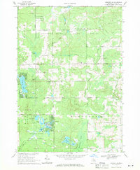
1969 Map of Meredith SW
USGS Topo · Published 1971About this map
Meredith and the surrounding woodlands of the Chippewa River State Forest characterize this late-1960s landscape in Clare County. The area is defined by its numerous glacial lakes and wetlands, including the cluster of Dodge Lake, Sand Lake, and Canada Lake, which are linked by small streams and marshy lowlands. The presence of an Old Railroad Grade cutting through the forest and numerous Gravel Pits suggests a history of timber extraction and resource development that shaped the local infrastructure. Rural community life is anchored by local landmarks such as the Amble Sch, the Church of God in Christ, and the Hamilton Cem. Significant natural features like Spike Horn Swamp and Popple Creek transition into the managed forest lands, while residential corridors have established along Townline Road and around the larger water bodies like Cranberry Lake.
Find a feature on this map
50 named features on this map. Tap any name to fly to it.
Don’t see what you’re looking for? This feature index may not catch every label — zoom into the map to look around manually.
Map Details
Editions of this 1969 Meredith SW Map
2 editions found

Other maps of this area

1954 · Traverse City
USGS Topo · 1:250,000

1954 · Midland
USGS Topo · 1:250,000

1957 · Harrison
USGS Topo · 1:62,500

1958 · Traverse City
USGS Topo · 1:250,000

1958 · Midland
USGS Topo · 1:250,000

1959 · Midland
USGS Topo · 1:250,000

1959 · Clare
USGS Topo · 1:62,500

1966 · Midland
USGS Topo · 1:250,000

1969 · Meredith NW
USGS Topo · 1:24,000

1969 · Meredith
USGS Topo · 1:24,000