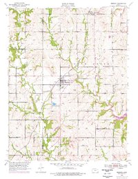
1952 Map of Meriden
USGS Topo · Published 1976About this map
Meriden serves as the central hub of this Jefferson County landscape, situated along the Atchison Topeka and Santa Fe railroad line. The map illustrates a rural transition period, with mid-century updates in purple showing the significant arrival of Perry Lake on the eastern edge of the quadrangle. Local civic life is anchored by landmarks like the Grange Hall and educational outposts including Sunbeam Sch and Dix Sch. The drainage patterns of Rock Creek, French Creek, and Muddy Creek define the topography, while the inclusion of the Radio Range Station and various radio towers points to the area's role in mid-century communication and aviation navigation. Water resources for recreation and agriculture are highlighted by Fin and Feather Lake, illustrating the varied land use across the Kaw and Rock Creek townships.
Find a feature on this map
24 named features on this map. Tap any name to fly to it.
Don’t see what you’re looking for? This feature index may not catch every label — zoom into the map to look around manually.
Map Details
Editions of this 1952 Meriden Map
4 editions found
Other maps of this area

1886 · Oskaloosa
USGS Topo · 1:125,000

1888 · Oskaloosa
USGS Topo · 1:125,000

1889 · Topeka
USGS Topo · 1:125,000

1894 · Oskaloosa
USGS Topo · 1:125,000

1894 · Topeka
USGS Topo · 1:125,000

1949 · Perry
USGS Topo · 1:24,000

1950 · Perry
USGS Topo · 1:24,000

1950 · Kansas City
USGS Topo · 1:250,000

1950 · Topeka
USGS Topo · 1:24,000

1950 · Grantville
USGS Topo · 1:24,000