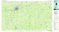
1984 Map of Meridian
USGS Topo · Published 1984About this map
Meridian Naval Air Station anchors the northern portion of this East Mississippi landscape, a region defined by the convergence of major rail lines and significant water management projects. By the mid-1980s, the urban center of Meridian had expanded toward the Bonita Reservoir, while the surrounding rural areas maintained a dense network of smaller communities like Vimville, Lockhart, and Kewanee. The hydrological character of the borderlands is prominent, featuring the Okatibbee Lake and its associated Okatibbee State Wildlife Management Area, alongside the winding course of the Sucarnoochee River.
Find a feature on this map
153 named features on this map. Tap any name to fly to it.
Don’t see what you’re looking for? This feature index may not catch every label — zoom into the map to look around manually.
Map Details
Editions of this 1984 Meridian Map
3 editions found
Other maps of this area

1921 · Meridian
USGS Topo · 1:48,000

1923 · Meridian
USGS Topo · 1:62,500

1929 · Epes
USGS Topo · 1:48,000

1932 · Epes
USGS Topo · 1:62,500

1948 · Mc Dowell
USGS Topo · 1:24,000

1949 · Mc Dowell
USGS Topo · 1:24,000

1953 · Montgomery
USGS Topo · 1:250,000

1953 · Andalusia
USGS Topo · 1:250,000

1953 · Hattiesburg
USGS Topo · 1:250,000

1953 · Meridian
USGS Topo · 1:250,000