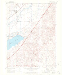
1951 Map of Merino
USGS Topo · Published 1972About this map
Merino and its surrounding agricultural valley depend entirely on the managed flow of the South Platte River, a landscape defined by an intricate network of irrigation systems. This mid-century survey illustrates the vital role of water rights in Northeastern Colorado, showcasing numerous gravity-fed channels such as the Company Ditch, Pawnee Ditch, and Davis Ditch. The presence of the Union Pacific railroad corridor alongside the river underscores the historical transport-water nexus that fueled the growth of these High Plains settlements. South of the river valley, the terrain shifts abruptly into the Sand Hills, where the expansive Prewitt Reservoir and its Prewitt Outlet Canal dominate the border between Logan and Washington Counties. This interface between the lush, ditched lowlands and the dry upland dunes reveals the stark engineering required to sustain regional farming and ranching during the early 1950s.
Find a feature on this map
15 named features on this map. Tap any name to fly to it.
Don’t see what you’re looking for? This feature index may not catch every label — zoom into the map to look around manually.
Map Details
Editions of this 1951 Merino Map
3 editions found
Other maps of this area

1951 · Willard
USGS Topo · 1:24,000

1951 · Messex
USGS Topo · 1:24,000

1951 · Sterling South
USGS Topo · 1:24,000

1951 · Merino SW
USGS Topo · 1:24,000

1951 · Merino SE
USGS Topo · 1:24,000

1951 · Merino
USGS Topo · 1:24,000

1951 · Atwood
USGS Topo · 1:24,000

1954 · Sterling
USGS Topo · 1:250,000

1958 · Sterling
USGS Topo · 1:250,000

1971 · Messex
USGS Topo · 1:24,000