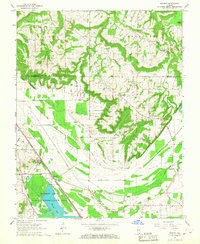
1966 Map of Mermet
USGS Topo · Published 1967About this map
Small farming communities and family cemeteries characterize the rural landscape of the Vienna and Grantsburg areas in the mid-1960s. The southern portion of this region is defined by the extensive drainage network of the Main Ditch and Bucker Pond Ditch, which feed into the large expanse of Mermet Lake. This reservoir is the centerpiece of the Mermet Lake State Conservation Area, a significant wildlife habitat established in a formerly swampy basin. The rail lines of the Chicago Burlington and Quincy and the Chicago Eastern Illinois intersect at Mermet, illustrating the area's importance as a transportation junction for Southern Illinois timber and agricultural products. Local genealogy is well-documented through numerous burial sites like Nineveh Cem, Clymore Cem, and the Masonic Cem, often located near crossroads such as Samoth and New Columbia.
Find a feature on this map
46 named features on this map. Tap any name to fly to it.
Don’t see what you’re looking for? This feature index may not catch every label — zoom into the map to look around manually.
Map Details
Editions of this 1966 Mermet Map
This is the sole edition of this map. No revisions or reprints were ever made.
Other maps of this area

1917 · Brownfield
USGS Topo · 1:62,500

1918 · Vienna
USGS Topo · 1:62,500

1919 · Vienna
USGS Topo · 1:62,500

1926 · Paducah
USGS Topo · 1:62,500

1928 · La Center
USGS Topo · 1:62,500

1929 · Paducah
USGS Topo · 1:62,500

1932 · La Center
USGS Topo · 1:62,500

1940 · Paducah
USGS Topo · 1:62,500

1942 · Vienna
USGS Topo · 1:62,500

1949 · Paducah
USGS Topo · 1:250,000