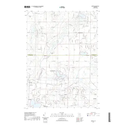
2018 Map of Merton
USGS Topo · Published 2018About this map
Glacial topography and several prominent waterways define the landscape around the Washington Co and Waukesha Co border. The Bark River and Oconomowoc River wind through a region characterized by numerous kettle lakes, including Lake Keesus, Friess Lake, and Lake Five. The historic village of Merton sits along the southern course of the Bark River, while smaller communities like Monches and Plat are situated further north. The presence of several small airfields, such as Erin Aero Airport and Doering Farms Airfield, indicates a mix of agricultural land use and aviation activity in this portion of southeastern Wisconsin.
Find a feature on this map
133 named features on this map. Tap any name to fly to it.
Don’t see what you’re looking for? This feature index may not catch every label — zoom into the map to look around manually.
Map Details
Editions of this 2018 Merton Map
This is the sole edition of this map. No revisions or reprints were ever made.
Other maps of this area

1892 · Waukesha
USGS Topo · 1:62,500

1892 · Oconomowoc
USGS Topo · 1:62,500

1901 · Waukesha
USGS Topo · 1:62,500

1904 · West Bend
USGS Topo · 1:62,500

1904 · Hartford
USGS Topo · 1:62,500

1906 · Waukesha
USGS Topo · 1:62,500

1909 · Oconomowoc
USGS Topo · 1:62,500

1957 · Madison
USGS Topo · 1:250,000

1959 · West Bend
USGS Topo · 1:62,500
1959 · Hartland
USGS Topo · 1:24,000