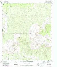
1972 Map of Mertzon SW
USGS Topo · Published 1988About this map
The Middle Concho River traverses the northern edge of this Irion County landscape, where the terrain is defined by a series of significant drainage systems including Big Hollow Draw and Seep Draw. This 1972 survey, later updated with revisions in the mid-1980s, reveals a rural Texas environment transitioning between traditional ranching and mid-century industrial expansion. Evidence of resource extraction is prominent throughout the quadrangle, with numerous Gravel Pits and various Drill Hole locations marking the hillsides. The southern reaches are characterized by the winding path of Lopez Creek and the long expanse of Rock Pen Draw, while scattered infrastructure like a prominent Radio Tower and an Oil Well punctuate the open country, showing the technological footprint of the era on the Edwards Plateau.
Find a feature on this map
12 named features on this map. Tap any name to fly to it.
Don’t see what you’re looking for? This feature index may not catch every label — zoom into the map to look around manually.
Map Details
Editions of this 1972 Mertzon SW Map
2 editions found
Other maps of this area

1895 · Sherwood
USGS Topo · 1:125,000

1920 · Barnhart
USGS Topo · 1:62,500

1921 · Ketchum Mountain
USGS Topo · 1:62,500

1922 · Barnhart
USGS Topo · 1:62,500

1923 · Ketchum Mountain
USGS Topo · 1:62,500

1954 · San Angelo
USGS Topo · 1:250,000

1958 · San Angelo
USGS Topo · 1:250,000

1965 · San Angelo
USGS Topo · 1:250,000

1971 · Noelke
USGS Topo · 1:24,000
1971 · Barnhart NE
USGS Topo · 1:24,000