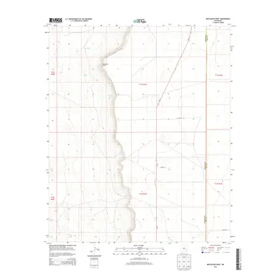
2013 Map of Mescalero Point
USGS Topo · Published 2013About this map
Mescalero Point defines the dramatic geological shift in this portion of the Llano Estacado, where the elevated plains of eastern New Mexico drop away toward the west. This 2013 digital survey illustrates the critical role of scarce water resources in this arid landscape, specifically marking Mescalero Spring and Graham Spring at the base of the escarpment. The division between Chaves and Lea Counties runs vertically through the eastern half of the map, north of Tabitha Rd. Man-made water catchments like Red Tank and Sikes Tanks are scattered throughout the lower terrain, supporting the ranching operations that utilize local routes such as Twin Tower Rd and Sharon Rd. The presence of these named tanks and springs highlights the long-term reliance on specific drainage points for both cattle and early travelers traversing the caprock.
Find a feature on this map
16 named features on this map. Tap any name to fly to it.
Don’t see what you’re looking for? This feature index may not catch every label — zoom into the map to look around manually.
Map Details
Editions of this 2013 Mescalero Point Map
This is the sole edition of this map. No revisions or reprints were ever made.
Other maps of this area

1954 · Brownfield
USGS Topo · 1:250,000

1958 · Brownfield
USGS Topo · 1:250,000

1962 · Brownfield
USGS Topo · 1:250,000

1973 · Culp Ranch
USGS Topo · 1:24,000

1973 · Mescalero Point
USGS Topo · 1:24,000

1973 · Soldier Hill
USGS Topo · 1:24,000

1973 · Caprock
USGS Topo · 1:24,000

1973 · Caudill Ranch
USGS Topo · 1:24,000
1973 · Oasis
USGS Topo · 1:24,000

1973 · Cooper-Good Ranch
USGS Topo · 1:24,000