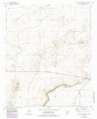
1973 Map of Mescalero Point NE
USGS Topo · Published 1985About this map
Mescalero Ridge the Caprock dominates this 1970s landscape, marking a sharp topographic break where the high plains drop away into Polecat Canyon. The map reveals a remote ranching and energy-producing environment on the border of Chaves and Lea counties, defined by vital water sources like Cottonwood Tank, a lone Spring, and the North Windmill. Human activity is primarily industrial and transit-oriented, evidenced by several Drill Hole locations and a large Pipeline cutting across the desert floor. A Roadside Park along the highway and a prominent Radio Tower indicate the area's role as a thoroughfare for travelers and a node for regional communication. The network of Jeep Trails provides the only access through this arid terrain, linking the isolated gravel operations and water tanks.
Find a feature on this map
12 named features on this map. Tap any name to fly to it.
Don’t see what you’re looking for? This feature index may not catch every label — zoom into the map to look around manually.
Map Details
Editions of this 1973 Mescalero Point NE Map
2 editions found
Other maps of this area

1954 · Brownfield
USGS Topo · 1:250,000

1958 · Brownfield
USGS Topo · 1:250,000

1962 · Brownfield
USGS Topo · 1:250,000

1973 · Culp Ranch
USGS Topo · 1:24,000

1973 · Mescalero Point
USGS Topo · 1:24,000

1973 · Soldier Hill
USGS Topo · 1:24,000

1973 · Caprock
USGS Topo · 1:24,000
1973 · Oasis
USGS Topo · 1:24,000

1973 · Mescalero Point NE
USGS Topo · 1:24,000
1978 · Presler Lake
USGS Topo · 1:24,000