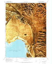
1968 Map of Messix Peak
USGS Topo · Published 1973About this map
The northern reaches of the Great Salt Lake define the lower margin of this survey, where the water meets an expansive Mud Flat. Rising sharply to the east and north, the Promontory Mountains dominate the horizon, with Mt Tarpey serving as a primary high point. This orthophotomap, based on 1960s aerial photography, provides a rare visual of the shoreline and drainage patterns before later lake level fluctuations altered the salt flats. Water sources in this arid environment are sparse but critical, evidenced by the presence of Rose Spring and a remote Well. Deep cuts into the mountain range, such as Maple Canyon and Broadmouth Canyon, show the primary paths for runoff and seasonal flow toward the basin.
Find a feature on this map
9 named features on this map. Tap any name to fly to it.
Don’t see what you’re looking for? This feature index may not catch every label — zoom into the map to look around manually.
Map Details
Editions of this 1968 Messix Peak Map
2 editions found
Other maps of this area

1954 · Brigham City
USGS Topo · 1:250,000

1958 · Brigham City
USGS Topo · 1:250,000

1961 · Thatcher Mountain
USGS Topo · 1:62,500

1962 · Brigham City
USGS Topo · 1:250,000

1966 · Thatcher Mountain SW
USGS Topo · 1:24,000

1967 · Golden Spike Monument
USGS Topo · 1:24,000

1967 · East Promontory
USGS Topo · 1:24,000

1968 · Messix Peak
USGS Topo · 1:24,000

1968 · Rozel
USGS Topo · 1:24,000

1968 · Indian Cove
USGS Topo · 1:24,000