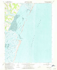
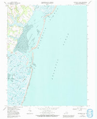
1968 Map of Metomkin Inlet
USGS Topo · Published 1971About this map
Metomkin Bay and the barrier islands of Accomack County define this coastal landscape, where complex tidal systems separate the mainland necks from the open Atlantic Ocean. The map reveals a series of prominent peninsulas including Parker Neck, Baylys Neck, and Joynes Neck, which are subdivided by deep-reaching waterways like North Fork Parker Creek and Folly Creek. Small rural settlements such as Parker, Walston, and Joynes are linked by a network of state routes, while the shoreline itself remains a maze of marshes and channels.
Find a feature on this map
55 named features on this map. Tap any name to fly to it.
Don’t see what you’re looking for? This feature index may not catch every label — zoom into the map to look around manually.
Map Details
Editions of this 1968 Metomkin Inlet Map
5 editions found
Other maps of this area

1931 · Accomac
USGS Topo · 1:48,000

1935 · Accomac
USGS Topo · 1:62,500

1942 · Mappsville
USGS Topo · 1:24,000

1942 · Wallops Island
USGS Topo · 1:24,000

1942 · Parksley
USGS Topo · 1:24,000

1943 · Parksley
USGS Topo · 1:31,680

1943 · Mappsville
USGS Topo · 1:31,680

1943 · Wallops Island
USGS Topo · 1:31,680

1946 · Eastville
USGS Topo · 1:250,000
1957 · Accomac
USGS Topo · 1:24,000